I set off at 15:44 with a simple mission in mind: to do at least 36 miles, to take the May total over 600 miles. A stiff wind was coming from the east which is awkward for a ride after work, because it usually leads to tangling with rush hour traffic near Zouch on the eastbound route. Nevertheless, I did head over that way regardless. Didn’t want to face a headwind on the way back.
Cooler than I expected. I did wear a few more layers this time but over the first half of the ride I was a little uncomfortable. It was cloudy as well. But nice and dry.
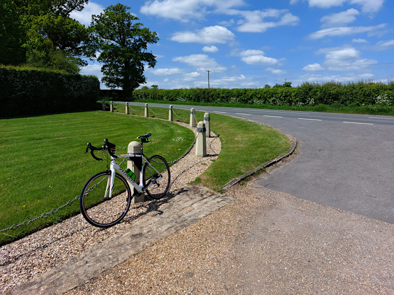
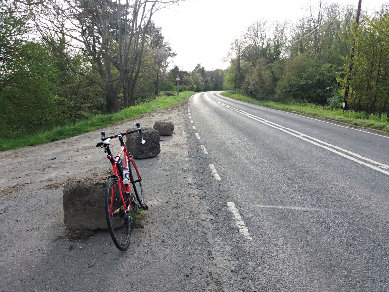
I got as far as Cotes then decided to take the road to Hoton, to do something a bit different. From there I took the “Lost Road” to Wymeswold for about a mile. Then I came back.
Went out a longer way through Coleorton and Diseworth, but came back down the quick way through Belton. I was much happier with a tailwind and a bit less traffic to contend with.
Not the most enjoyable ride over the first half, but happy to have clocked up 603 miles for May. 2553 this year.
Too windy to do a particularly long one today. I didn’t want to get up early and I had other things to do this afternoon. I thought 40 or so would do.
I set off at about 10:20, on my usual eastbound route. After 23 miles I took a left turn along a road called Lawn Lane to Old Dalby. I thought I’d just explore for a mile or so then come back the same way, but it was a nice quiet road so I kept going. I came to a T junction with a sign to Wymeswold, so I took that. From this point I was on a road that runs parallel and to the north of the usual eastbound route. I have taken it a few times, but not for a couple of years. Must do it again some time soon. The only downer really is that the road surface is mostly poor.
Back the usual way from Wymeswold, except that I elongated the ride a bit by coming home through Griffydam and Coleorton.
I wore minimal clothing, shorts and a light short-sleeve top. Nice on the way back when conditions had warmed up a bit and I had a tailwind, but I was a bit too cool for the first hour or two, except when the sun came out.
Still – an enjoyable run out, particularly nice to do something a bit different. Will see if I can incorporate Lawn Lane into a new route.
I listened to Beggar’s Banquet by the Rolling Stones, then my MP3 player app cued up the next album by alphabetical order. Beings by Lanterns on the Lake. I didn’t recognise it at first, thought it might be some obscure Sinead O’Connor record I’d forgotten about. What a brilliant, intense record.
I used my Casio GPS watch to track the ride, something I don’t do that often because although I really like the watch, the app it connects to and the Casio online service are crap. And although the app managed to register the activity, it hasn’t uploaded it to Strava.
Would be nice if the Casio site offered the facility to export tracks to files, but it doesn’t. So at the moment this is all I have to show for it:
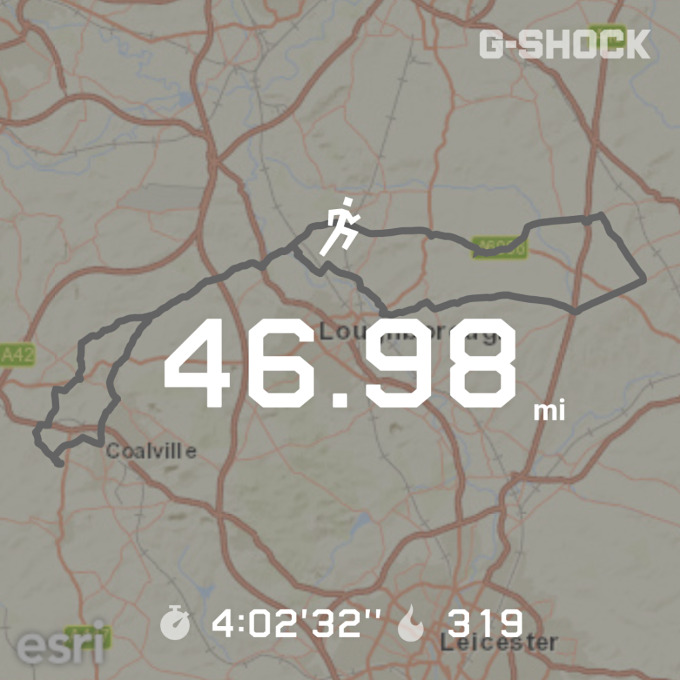
I didn’t get the watch synced to the satellites until 0.39 miles into the ride so that’s 47.37 miles, 565 this month.
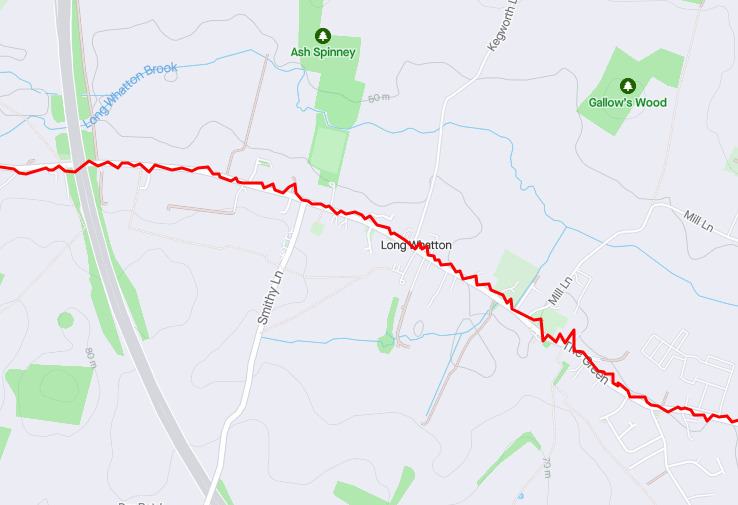
Another dry, warm day – a little cloudier than Wednesday but more irritatingly, a fairly stiff breeze was coming from the east. I set off with the vague intention of doing some of the eastbound route, but after 9 miles or so I turned left for Long Whatton. The headwind was annoying me and I decided the rush hour traffic on the other side of the A6 would annoy me even more.
I went as far as the airport, then came back down a longer way than usual down through Belton, Griffydam and Coleorton. Much nicer with a bit of a tailwind.
I used a GPS tracking app on my phone, imaginatively titled ‘GPS Logger’ to record the ride. I’d thought I’d probably only managed about 23 miles, but once I uploaded the track, Strava claimed 30.38!
Oddly the app itself claims 27.4, so where Strava has got the additional three miles from, I have no idea. But even 27.4 seemed a bit suspect so I recreated the route as a track in RideWithGPS, and that claims 26.3. I’ll take that. It seems a bit more likely.
Interestingly, the track that the phone app has recorded is bizarrely jagged and wonky. Technology, eh?
Actually I’ve just loaded the track into a GPX editor (GPSPrune) and smoothed out the kinks using a track compression algorithm, and now it measures as 26.5. So I think the RideWithGPS figure is close enough. I’ll go with that.
A dry, warm, sunny afternoon – exactly the sort of conditions you’re dreaming about when you’re chugging along in the cold and dark in January with more layers on than an astronaut, waiting for your toes and fingers to go numb.
Well – perhaps a little blowier than I’d have liked, with a moderate wind coming from the north-west. With that in mind I was going to do some sort of route up to Derby and back but just before the turn for Coleorton I reminded myself that the rush hour traffic would make it annoying, so I decided to do a Twycross Bypasser instead.
I did a longish version – right across to Kisses Barn Lane, along Mythe Lane and Atterton Lane to Fenny Drayton along the bottom then back up and across along Fenn Lanes.
Pedalling up through the villages north of Bosworth in late afternoon sunshine is one of life’s great joys, and the headwind only compromised it slightly.
Witnessed a minor altercation between a silver Ferrari and an old Fiesta near Packington. The driver of the Ferrari, a blonde lady of a certain age, should have given way but didn’t. The Fiesta driver wasn’t having it, so they ended up facing off in the middle of the road until she pulled in. She looked a little put out as I passed her; perhaps her sense of entitlement needs to be moderated a little.
My right shoe didn’t have any lateral adjustment in the pedal when I set off and twisting my foot to try to free it up didn’t seem to help matters. I inspected the cleat at Witherley and removed some compacted dry mud with a stick. It was fine after that.
Back on 39.09 miles. Lovely run out. 491 done this month.
I was going to do 80 or 90 today, but I woke up earlier than I expected and I was pedalling away from the garage by 0725. I did want to avoid leaving that early because I assumed it would be uncomfortably cold, but with tights and a fleece on I was fine.
Sunny from the moment I left the house. Really nice out there.
The wind was coming from the north-east. I did consider going up to Newark today, because I haven’t done that so far this year. But in the end I settled on the easy option, the eastbound route. The road surface would be better and I wouldn’t have to faff around with my eTrex or a navigation app on a phone.
Stopped after 23 miles and stuffed my tights, fleece and rear light into my camo bag, which I then stashed in a hedge. It was very unlikely that I’d need a rear light on this ride, but even less so before the last 23 miles. Having said that, I’ve noticed that some riders do like a flashing rear light even in bright sunlight. But I don’t bother with that myself.
There are two options after Buckminster; one involves dipping down into Rutland and going east through South Witham and Little Bytham. But I did the other one today; through Stainby, Corby Glen and Grimsthorpe. Got as far as Edenham, then turned back having done 53 miles.
Took the pic at the entrance to Grimsthorpe Castle.
UV levels were high today so I took a Zinc Stick with me and applied a coating of Zinc Oxide to my nose. Not the full Shane Warne; just a thin coat. This particular product is yellow rather than white. I did feel a bit self-conscious going into the village shop at Buckminster with a yellow hooter.
Sunday’s not the best day for a long ride really because the shops tend to be closed in the afternoon and the only petrol station on this route is at Burton on the Wolds, 17 miles from home. So I had to stock up at Buckminster on the eastbound leg, early on.
Lovely out there and I wasn’t too hot in the afternoon; the breeze kept me cool. But I must devise some new routes.
Started the next Reacher novel (Bad Luck and Trouble) but the wind noise made it hard to listen. I must get some wind noise absorbers. They are actually a thing. You attach them to cycle helmet straps. In my case I’d have to improvise something for those times I don’t wear a helmet (most of the time to be honest).
Did manage to listen to West Ham vs Leeds on the DAB in the afternoon.
Wanted to do about 40 after work. The wind was coming from the north-west again. Took the slightly longer route up to Swarkestone Bridge through Isley Walton, then instead of going left along the Beloved A Road, I turned right to go through Weston and Aston-on-Trent. Then west toward Derby.
Stopped when I got to the bypass roundabout – which I dislike, because it wasn’t a feature of that road when I used to commute along it 30-odd years ago. Then I turned and came back home exactly the same way, except for a half-mile deviation in Coleorton.
Nice out there, warmer than I expected and I slightly overclothed myself. Quite bright, but cloudy until the sun came out for the last mile. Back on 39.23.
Didn’t think I’d much feel like cycling after 160 miles of driving today and I didn’t really, but since the weather was nice and I hadn’t been out on a bike for over a week, I thought I’d make the effort. About 90 minutes after parking the car on the drive following a weekend away in Norfolk, I was mounting Boardman II.
With the wind coming from the north-west, I decided that a trip up over Swarkestone Bridge and west along the Beloved A Road was in order. I wanted to do about 40 miles.
I went up via Top Brand and Isley Walton. I especially like to glide along Top Brand in the sunshine. Turned back a couple of miles after Hilton and came back via Wilson and Breedon on the Hill, to avoid Rotter’s Rise after Melbourne.
Unusually cool for this time of year when I set off, I thought. So I wrapped up warm. Should have taken a backpack so I could remove the tights and a top layer, and possibly my woolly hat because the temperature had climbed quite a bit by 4pm.
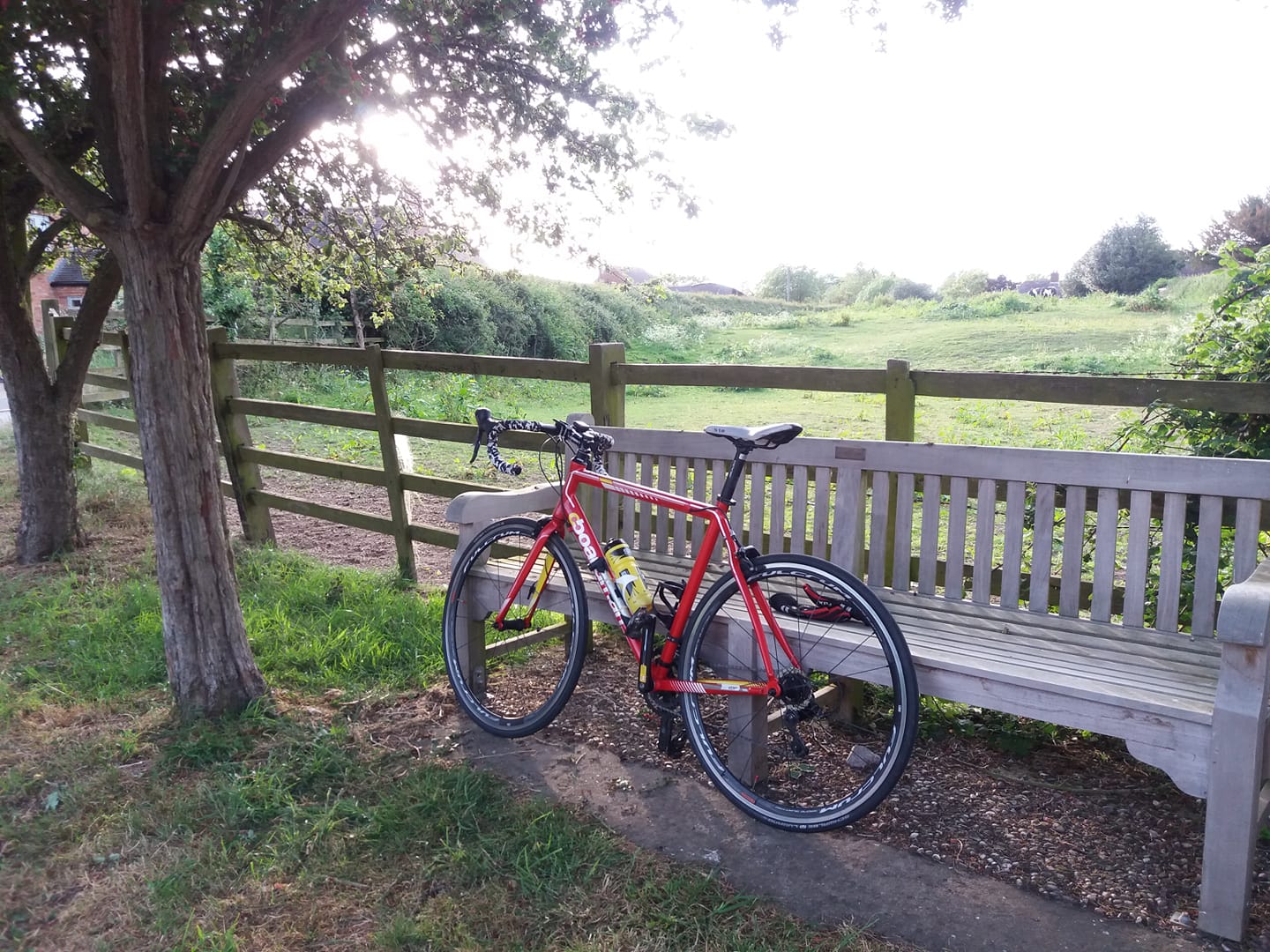
The second Boardman has had new bar tape since last time it had a run out, and the new tape performs pretty much exactly like the old tape – which is fine. The important thing is that it’s dark grey instead of a highly impractical shade of bright yellow.
A dry day, warm in the afternoon with a light wind from the west was forecast for yesterday. Sunset at 8:44pm. A perfect day really for a Wales trip, especially on the sixth anniversary of my first ride there and back.
I set an alarm on Saturday night for 04:45, but woke at 04:30 and was out of bed a minute later. I set off at 05:48.
This was my third ride to Wales and back. I’d chosen a substantially different route this time. My destination point just to the west of Whitchurch was the same, but the last 30 miles to get there would take me through Eccleshall, Loggerheads and Market Drayton, to the south of the usual route. I’d also planned to go a different way for a short stretch of the route between Handsacre and Colton, to bypass Rugeley.
Cool for the first couple of hours after I set off, but I was wearing adequate clothing and was comfortable. All went very smoothly until I powered up my Garmin eTrex handlebar-mounted navigation unit to guide me through the new stretch past Rugeley.
The first problem was that its batteries were dead. I transferred the AAs from my DAB personal radio. The second problem was that the new route I’d transferred to it wasn’t available from the GUI. Even in files of the same protocol there can be minor differences in format and I can only assume that the Garmin didn’t like the particular GPX file that I’d generated in a route-planning app.
Of course, I should have checked the eTrex before I set off. Oh well – I only needed the assistance of a mapping tool for a relatively short part of the route and found my way easily enough using Google Maps, but it was a pain to have to stop and consult a phone. I did use the eTrex in its basic mapping mode and that was useful to a degree. So I left the batteries in it and bought some more AAs at a petrol station a few miles further on to power up the DAB again.
To be honest, a decent phone with a GPS navigation app is a much better proposition in most cases than an eTrex. The screen is always bigger and clearer on a modern phone and you can easily buy handlebar mounts for them. However – on a long ride, I like the fact that the eTrex takes conventional batteries, because you can buy them at any petrol station and they hold a longer charge than the rechargeable unit in a phone. But I’m starting to think that taking two phones, or perhaps a power bank might be a better bet.
The road through the village at Eccleshall had been closed for a Coronation street party, but I guided the bike carefully through the barriers and weaved a careful path through the celebrants. At Market Drayton, a road race was taking place and once again the road was closed. Once again I just ignored this, so I had to dodge oncoming athletes before finding a detour. Annoying.
Just outside Market Drayton there’s a brand new housing estate, with the front doors of gleaming new properties bearing a sign saying “I could be your new dream home”. But directly across the road, there’s a site with a huge sign that announces “GYPSY / TRAVELLER SITE COMING SOON, PLANNING PERMISSION APPROVED”. New nightmare home, more like. You couldn’t pay me to live there.
By 1100 or so the sun was out and the temperature had climbed very nicely, so I removed a layer of clothes and sealed them in a plastic bag. I packed them into a camouflage pattern nylon drawstring bag which I then stashed in a hedge just off the road next to a farm gate. Much better than carrying them around in a backpack for the next 40-odd miles.
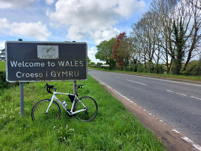
I arrived at my destination, the border between England and Wales, at around 1330. I pedalled across it for about 150 metres then turned back. Interestingly the sign on the other side of the road reads “Welcome to SHROPSHIRE” rather than “Welcome to ENGLAND”.
On the whole I wasn’t really that impressed with the new route. It was OK, but a little busier and less scenic than my traditional Wales route. I probably would have come back the old way if not for the need to pick up my clothes on the way back. I’d thought the traffic would be quiet on the middle day of a public holiday weekend but no, not really.
By the time I reached Eccleshall again the street party was in full swing, with a band belting out Cranberries covers from the side of a truck. A bit harder to weave through the revellers and I had to resort to riding along the pavement.
I didn’t much like the detour I’d taken around Rugeley on the outbound part of the route, so I didn’t bother with it on the way back. But I missed a turn for Kings Bromley and gave myself a few more miles to do.
Beautiful out there in the warm sunshine on the way back, especially with a light tailwind. Newcastle vs Arsenal kept me entertained for a couple of hours in the afternoon. I also listened to the Rolling Stones’ ludicrous (if interesting) 1967 psychedelic bandwagon-jumping album Their Satanic Majesties Request. There are a couple of good songs on it. I like 2000 Man, which was covered by Kiss on Dynasty. But mostly it’s terrible.
Back on 151.27 miles, a few minutes after sunset. 261 done this month.
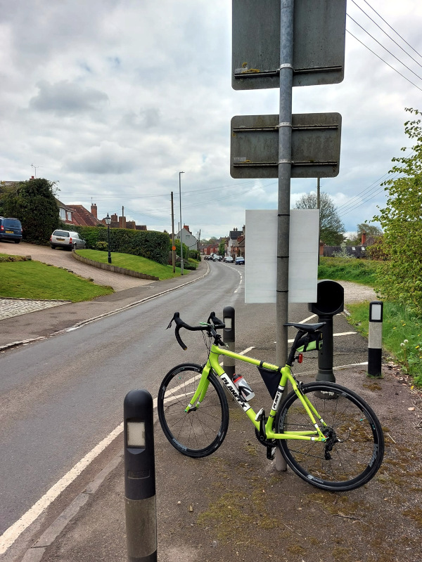
A dry, sunny day today. With rain in the forecast for most of the next couple of weeks, clearly a decent run out after work was in order. Forty miles or so, I thought.
Quite an annoying moderate / strong wind coming from the east. I thought I’d do 20 miles or so of the Eastbound Route then come back. That’s pretty much what I did, except that I detoured via Top Brand through Diseworth on the way out (I sometimes do that on the way back, but rarely going east). I got as far as Narrow Lane after 23 miles, then detoured through Wymeswold and Rempstone on the way back. A sort of figure-of-eight route.
A bit cooler than I’d have liked but I got away with bare legs. I took the Boardman to assess the performance of its new bar tape. Apart from looking cheap, it’s not quite as comfy as the old tape. I may wrap some more tape directly over it, for a dual-ply super padded arrangement.
Back on 43.21 miles, that’s 110 for the month already. I’m aiming to do 435 this month.
I had a tentative intention to ride to Wales and back today. I decided that if I woke up early enough and I felt like it, I’d do the necessary 140-odd miles to penetrate the land of dragons, leeks and Gareth Bale.
I did wake up at about 0400, but I only got as far as the bathroom before going back to bed. After all long bike rides are a lot of fun, but sleep’s nice as well, isn’t it?
I got up again at about 0830 though, and I’d set off on a bike by 0940 with the more modest goal of doing a fondo.
The weather forecast prompted me to go west, for two reasons – firstly, it wasn’t going to rain over that way (whereas it was going to, supposedly, at home) and secondly the wind was coming from that direction.
I decided on my Upper Westbound Route, up over Swarkestone Bridge then west along the Beloved A Road.
Annoyingly I left my GPS bike computer in the house, so I tracked the ride using the RideWithGPS app on my phone. This meant of course that I wouldn’t have a view of the distance I’d done without stopping to take out the phone, but I’ve memorised a few distance points on that route. I knew when I’d done ten miles, and fifteen, and twenty without checking the phone.
By the time I got to Sudbury after 25 miles, I’d decided to do something a bit different than just going back the same way. I decided I’d go south to join my Lower Westbund Route through King’s Bromley, Edingale, Lullington and Measham. I’ve done this before a couple of times and was a bit reluctant to do it, because it involves a punishing rollercoaster of brutal hill climbs. But I resolved to grin and bear it.
The other problem is that the whole route doesn’t quite add up to the requisite fondo distance. So to compensate, I opted to go a bit further west for a bit. Therefore, after about five miles of heading south down from Sudbury, I took a right turn for Hoar Cross. I knew I could get to Abbots Bromley easily from there, a few miles to the west. And that’s a familiar destination from the Lower Westbound Route.
Unfortunately the road from the main road to Hoar Cross offered a fast, steep descent over a bumpy surface well furnished (today at least) with puddles, so the bike and I picked up a few splashes. I won’t take that turn again. I stopped at a bus shelter when I got to the village to consume the food and tinned coffee I’d bought at a petrol station a few miles previously. Then I set off to Abbots Bromley, about three miles further on to the west. A much better road from that point on.
Wasn’t sure if coming home my usual way from Abbots Bromley on the lower route would see me home on a fondo distance – so I kept going west through the village for a mile or two before turning for home. I didn’t need to, as it turned out. I’d done 66.62 miles when I arrived back at the garage.
As I negotiated the right turn into Grangewood Road between Lullington and Acresford about ten miles from home, I took the trouble to return a smile and a wave to two cyclists coming the other way. A motorist at the junction took great offence at this. He beeped his horn and gesticulated aggressively, as if I was inconveniencing him. I hadn’t even slowed down, but you’d think I’d parked my bike in front of his car. Unbelievable. I gave him a withering look and a slight shake of the head, intended to convey a sense of disbelief blended with pity.
Really a very nice run out. The Lower Westbound Route is a lovely proposition on a sunny day. Nice and warm as well, later on. I stopped after fifteen miles to remove my tights and an upper layer and stuff them in my back pack.